It was late July. We had the boat stocked up and were waiting for a decent forecast to head for Venezuela, but there had been no wind now for about a week. Then Catherine had been unwell over Wednesday night and she was no better Thursday, so we decided that she'd visit the doctor on Friday. Going to bed, I dismissed the beginnings of a headache I was feeling as the result of the stresses of the day. Neither of us slept well, and my headache got progressively worse, by morning there were two of us for the Doc, and he was quick to confirm our fears that we both had Dengue.
He gave us a prescription, each tablet contained 500mg paracetamol and 30 mg codeine, take one or two up to four times daily. Outside the pharmacy we both gobbled up two tablets each like bold children.
We normally do our week's shopping on Friday, so we forced ourselves around the supermarket, the drugs effective against the headache, but combined with the fever to turn us into zombies. For most of it we shouldn't have bothered, Catherine had already lost her appetite, and I was losing mine, I managed a small meal on Friday and Saturday before the nausea took hold.
I'm not sure when the headache went away, but by Sunday I was too nauseous to notice. The nausea and fever continued all week, while at the same time I went through a few days constipation, followed by a few days of diarrhea. I found that lying down the nausea abated some, and taking two of the tablets every six hours ensured that I was asleep, or at least not conscious, for a good 15 hours a day.
By Monday, the trip from bed to heads, a journey of perhaps 20 feet, I found impossible without a five minute lie down rest en route. By Wednesday we were getting concerned at our lack of nutritional input. I had been managing a glass of orange juice every day, but Catherine's diet was 100% water, the only things we thought we might be able to stomach, chicken broth and toast, meant a couple of minutes standing in the galley. By Thursday, taking it in turns we were able to do this. Chicken noodle cup of soup, diluted by 50%, and a slice of toast, heavily buttered, after fasting for a week I've got to have a few credits in the cholesterol bank!
On Friday, a neighbouring boat offered to do some shopping for us, although we needed little more than bread for toast and chicken noodle cuppa-soups, we were very grateful, neither of us was up to a trip to the shop. Over the weekend we progressed to eating boiled eggs (spooned out of their shells into a cup, with cholesterolly suicidal amounts of butter, yum! – I was never really responsible with credit).
On Tuesday we ventured out on the dinghy, just as far as the Marina at Calvigny, perhaps a half a mile dinghy ride. By the time we got there we were exhausted, but after a mineral and a rest in the big comfy chairs by the pool we were sufficiently restored to contemplate a light lunch, our first real meal in almost two weeks.
By the next Friday, two weeks after we had gotten sick, we were fit enough to do our own shopping, Today, four weeks on, we were still not quite back to normal, tiring easily and are still feeling a bit lethargic, but getting better all the time.
Although we got one of the less dangerous strains, Dengue fever is still one nasty disease, we had the bad luck to both get it at the same time. Perhaps the infecting mossies are hunting in packs!
Monday, October 25, 2010
Saturday, July 3, 2010
Cruising the Caribbean, St Vincent and the Grenadines
North Atlantic
View Larger Map
Caribbean
View Larger Map
Leewards & Windwards
View Larger Map
The Windwards refer to the island chain from Martinique in the North to Grenada in the South. The Leewards are the islands from Dominica north.
Martinique
View Larger Map
Martinique is a Department of France. We chose it as our arrival point after the Atlantic crossing because we thought it would be like arriving in France. Well, some French people we met described it as "Yes, it's France, but it's not France". To me the place felt more like a French speaking third world country, although a pretty affluent third world country at that.
We stayed for a total of 6 weeks, partially to recover from the crossing, partially to make repairs to the things that broke on the way over, and of course to visit the island & see the sights.
Martinique, Le Marin
View Larger Map
This is a deeply indented bay in the southeast tip of the island. For anyone in a boat, this means lots of shelter. There can be some fairly big waves out at sea, but short of hurricane conditions the bay is like a lake, so no rolling around in the swell. However, it also means lots of boats. There is a 600 berth marina, and up to twice that number of boats anchored off. There are some more isolated spots around the bay, if you don't mind the long dinghy ride into town.
At least one river flows into the bay, so the water is a bit murky. Because of the murkiness and all the boats, we never felt comfortable about swimming here. We moved out to St Anne (scroll above map down slightly) at the entrance to Le Marin bay to scrape off the goose barnacles that grew on our hull while we were crossing the Atlantic. However we had to put up with rolling around in the swell while we were there.
Martinique, Fort de France
View Larger Map
A little further North is the capital of Martinique, Fort de France. Although also sheltered from the elements, the anchorage is right beside the ferry terminal, and with ferries coming and going every few minutes from early morning through until evening it got very rolly from their wakes.
Although a much bigger town than Le Marin, it is nowhere near as yacht friendly. There is one chandlers, and plenty of supermarkets, pubs etc., but it is a town focused on being capital of the Island, rather than on the boats anchored off.
St Pierre
View Larger Map
St Pierre in the North, is virtually not sheltered at all, but worth a visit in calm weather because of the volcano and its history.
St Lucia
View Larger Map
This is the next island south in the Windwards. It is an independent country.
Near to the northern tip on the West coast there is a reasonable anchorage in Admiralty Bay, which is the area just south of Pigeon Island. It is open to the West, but the winds normally don't come from that direction.
View Larger Map
However the lagoon just off it, Rodney Bay, is a natural harbour, and is sheltered from all directions. Nowadays, the lagoon is filled with a couple of marinas, private docks on shoreside properties, and what space is left over is taken up with moorings. So it is no longer possible to anchor there.
The "Googlemaps" version of Marigot Bay is nothing like the place we visited, so I won't bother sticking up their map.
Soufriere and the Pitons.
View Larger Map
Soufriere is a pretty town, dominated by the Pitons, twin volcanic peaks that provide a dramatic foreground to the landscape. The whole area is a national marine park, and anchoring is forbidden. Moorings are provided for about EC$20, = about €6.50, a night. We picked one up about half a mile west of the town, in an area with the unlikely named of "the Bat Cave"!
There is a customs office in Soufriere where we were able to check out of St Lucia before departing for St Vincent.
St Vincent and the Grenadines
View Larger Map
The big Island in the north of the above map is St Vincent, and the Grenadines are the collection of little ones running south from it. All except the biggish island in the South of the map, and one of the tiny islands off it, which are Carriacou and Petit Martinique respectively, which are part of the country of Grenada.
We were advised that the entire northern half of St Vincent is cannabis growing country, lawless, and if we stopped there we would almost certainly be boarded by armed robbers. So we kept going until we reached a small bay about half way down the west coast called Wallilabou. Here there is a customs office, a hotel, a museum, and nothing else. Nothing that is, except the remains of the film set from the Pirates of the Caribbean. In fact the museum was part of the set, with nothing but a facade held up by scaffolding hidden behind it. But they put a roof over the scaffolding and made it weatherproof, then filled it with photos and other memorabilia from the making of the movies.
Again Googlemaps shows Wallilabou in the wrong place, so no point in zooming in on the map.
Here are some pictures we took there, see if you can spot anything familiar from the movies.


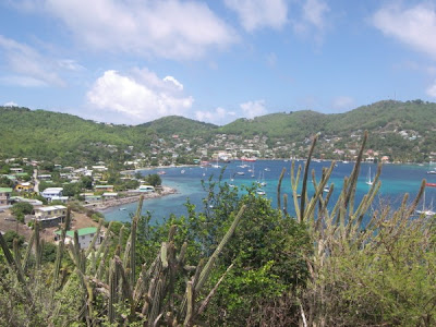
We didn't stop anywhere else in St Vincent, instead heading for our first Grenadine, Bequia. The massive sheltered bay on the west coast at Port Elizabeth makes it a popular spot for yachts.
View Larger Map
Looking at the map, the entire island looks like a harbour built around the anchorage. If you're wondering why all the anchorages are along the west coasts of the various islands it is because the trade winds blow almost constantly all year round from the east, so the West coasts are the sheltered side.
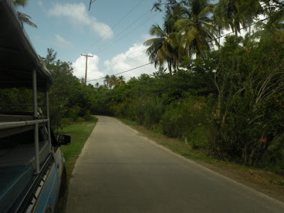
We met up with an American couple, Bill & Susan, and the four of us took a taxi on an island tour. Well, they call them taxis here, at home they call them pick up trucks, you just climb up on the back. Our taximan took the job to heart, and was proud to tell us about his island.
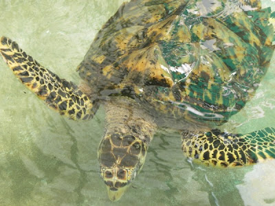
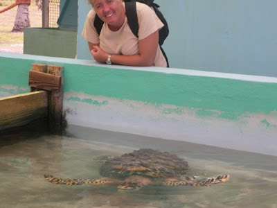
The tour also took in a turtle rescue centre. Pictures show the taxi, the anchorage, and a few sites from around the island.

Further south we visted the Tobago Cays, which are a handful of small islands and reefs. We anchored behind the reefs facing East into the Atlantic, the reefs protect you from the swell, but with nothing but ocean in front of us for two thousand miles to Africa. Sitting in the trade winds kept our wind generator spoinning, and it was great to see full batteries all the time.
View Larger Map
Caribbean
View Larger Map
Leewards & Windwards
View Larger Map
The Windwards refer to the island chain from Martinique in the North to Grenada in the South. The Leewards are the islands from Dominica north.
Martinique
View Larger Map
Martinique is a Department of France. We chose it as our arrival point after the Atlantic crossing because we thought it would be like arriving in France. Well, some French people we met described it as "Yes, it's France, but it's not France". To me the place felt more like a French speaking third world country, although a pretty affluent third world country at that.
We stayed for a total of 6 weeks, partially to recover from the crossing, partially to make repairs to the things that broke on the way over, and of course to visit the island & see the sights.
Martinique, Le Marin
View Larger Map
This is a deeply indented bay in the southeast tip of the island. For anyone in a boat, this means lots of shelter. There can be some fairly big waves out at sea, but short of hurricane conditions the bay is like a lake, so no rolling around in the swell. However, it also means lots of boats. There is a 600 berth marina, and up to twice that number of boats anchored off. There are some more isolated spots around the bay, if you don't mind the long dinghy ride into town.
At least one river flows into the bay, so the water is a bit murky. Because of the murkiness and all the boats, we never felt comfortable about swimming here. We moved out to St Anne (scroll above map down slightly) at the entrance to Le Marin bay to scrape off the goose barnacles that grew on our hull while we were crossing the Atlantic. However we had to put up with rolling around in the swell while we were there.
Martinique, Fort de France
View Larger Map
A little further North is the capital of Martinique, Fort de France. Although also sheltered from the elements, the anchorage is right beside the ferry terminal, and with ferries coming and going every few minutes from early morning through until evening it got very rolly from their wakes.
Although a much bigger town than Le Marin, it is nowhere near as yacht friendly. There is one chandlers, and plenty of supermarkets, pubs etc., but it is a town focused on being capital of the Island, rather than on the boats anchored off.
St Pierre
View Larger Map
St Pierre in the North, is virtually not sheltered at all, but worth a visit in calm weather because of the volcano and its history.
St Lucia
View Larger Map
This is the next island south in the Windwards. It is an independent country.
Near to the northern tip on the West coast there is a reasonable anchorage in Admiralty Bay, which is the area just south of Pigeon Island. It is open to the West, but the winds normally don't come from that direction.
View Larger Map
However the lagoon just off it, Rodney Bay, is a natural harbour, and is sheltered from all directions. Nowadays, the lagoon is filled with a couple of marinas, private docks on shoreside properties, and what space is left over is taken up with moorings. So it is no longer possible to anchor there.
The "Googlemaps" version of Marigot Bay is nothing like the place we visited, so I won't bother sticking up their map.
Soufriere and the Pitons.
View Larger Map
Soufriere is a pretty town, dominated by the Pitons, twin volcanic peaks that provide a dramatic foreground to the landscape. The whole area is a national marine park, and anchoring is forbidden. Moorings are provided for about EC$20, = about €6.50, a night. We picked one up about half a mile west of the town, in an area with the unlikely named of "the Bat Cave"!
There is a customs office in Soufriere where we were able to check out of St Lucia before departing for St Vincent.
St Vincent and the Grenadines
View Larger Map
The big Island in the north of the above map is St Vincent, and the Grenadines are the collection of little ones running south from it. All except the biggish island in the South of the map, and one of the tiny islands off it, which are Carriacou and Petit Martinique respectively, which are part of the country of Grenada.
We were advised that the entire northern half of St Vincent is cannabis growing country, lawless, and if we stopped there we would almost certainly be boarded by armed robbers. So we kept going until we reached a small bay about half way down the west coast called Wallilabou. Here there is a customs office, a hotel, a museum, and nothing else. Nothing that is, except the remains of the film set from the Pirates of the Caribbean. In fact the museum was part of the set, with nothing but a facade held up by scaffolding hidden behind it. But they put a roof over the scaffolding and made it weatherproof, then filled it with photos and other memorabilia from the making of the movies.
Again Googlemaps shows Wallilabou in the wrong place, so no point in zooming in on the map.
Here are some pictures we took there, see if you can spot anything familiar from the movies.


We didn't stop anywhere else in St Vincent, instead heading for our first Grenadine, Bequia. The massive sheltered bay on the west coast at Port Elizabeth makes it a popular spot for yachts.
View Larger Map
Looking at the map, the entire island looks like a harbour built around the anchorage. If you're wondering why all the anchorages are along the west coasts of the various islands it is because the trade winds blow almost constantly all year round from the east, so the West coasts are the sheltered side.
We met up with an American couple, Bill & Susan, and the four of us took a taxi on an island tour. Well, they call them taxis here, at home they call them pick up trucks, you just climb up on the back. Our taximan took the job to heart, and was proud to tell us about his island.
The tour also took in a turtle rescue centre. Pictures show the taxi, the anchorage, and a few sites from around the island.


Further south we visted the Tobago Cays, which are a handful of small islands and reefs. We anchored behind the reefs facing East into the Atlantic, the reefs protect you from the swell, but with nothing but ocean in front of us for two thousand miles to Africa. Sitting in the trade winds kept our wind generator spoinning, and it was great to see full batteries all the time.
Friday, June 11, 2010
Checking in and out
We're all used to Immigration and Customs controls in airports and ferry ports. You arrive into a country and there's usually one or two lots of officialdom you've to pass through, the guy that looks at your passport, (sometimes he stamps it and others he just nods vacantly as you hold it up as you pass him by), and then there's the “green” or “red” zones of “anything to declare”. We sometimes deal with the port authorities slightly more subtly in the “taxes” added to our air fares, but sometimes they collect a fee from you as well. But whichever the system, crossing an international borders has become a fairly streamlined, and the ports are set up to deal with arrivals by the boatload or planeload..
But supposing you are arriving in your own little boat, and your first port of call can theoretically be anywhere, as you can drop anchor off any piece of coastline. So there's a process.
Certain ports are designated as ports of entry, and you must make one of these your first port of call. On arrival you hoist a yellow flag. This flag represents the letter Q, for quarantine. Strictly speaking you then wait for officialdom to contact you, and traditionally they made sure you weren't bringing disease into the country. These days most places let the skipper come ashore, with passports and boat papers, and they check you in in the comfort of their office. Some places are even more flexible. However, friends of ours arriving in Morocco had to stay on their boat until a guy in a space suit came and checked them for swine flu, once passed, they were warmly welcomed into Morocco.
Within the EU, we didn't have to bother with checking in. Frequently, if and when you arrived at a marina the office passed on your details to whatever branches of officialdom required them, otherwise you were subject to random checks, which averaged for us about once every six months. However, the situation for non EU boats is probably different.
Outside of the EU the situation can vary. In Rodney Bay, St Lucia, the Immigration, Port, and Customs each had a desk in a tiny little office that you squeezed into. You filled out a form with three carbon copies, and then visited each desk in turn, leaving one copy and a little money with each official, keeping the last copy for yourself. In other places the offices are in different buildings, or even different towns, and it can be quite a run around. Even after you have gone through all of this in some countries, they require that you check in and out of every subsequent port you visit. In the Cape Verdes they even hold onto your boat papers while you're there. Most places only require that you check out when you are leaving the country.
Martinique was the simplest, where I just went into the customs office, sat at a PC and filled out an on-screen form, printed it, and brought it to the counter where it and our passports were stamped. The only odd thing there was that Martinique, as you may have read recently, is part of France (well a Department of France), and thus in the EU, where I as I previously implied they don't seem overly bothered with your papers at all.
One other document that they require when you arrive is your check out papers from the last country you've been to, so if you try to sneak in without paying the taxes and visas, you will have an unaccounted gap in your paperwork, so don't try it!
Beware though, if you think these little inconveniences tiresome with a mindset of countries like Ireland, Britain, France, etc., because when you get to the Caribbean most of the countries are smaller than a small Irish county, and crossing international frontiers is a routine event.
Caribbean Geography
The Antilles is the collective name for the Islands of the Caribbean, the Lesser Antilles being the smaller islands, that means excluding Cuba, Jamaica, and the single island that accommodates the countries of Haiti and the Dominican Republic.
View Larger Map
The Lesser Antilles are subdivided into the Leeward Islands, running as far south as Dominica, and the Windward Islands stretching from Martinique down to Grenada. I should point out, Dominica the island is a country onto itself, and is nothing to do with the Dominican Republic, except of course that they are both fellow Antilles.
St Vincent and the Grenadines is a country made up of one big Island, called “St Vincent” and a cartload of smaller ones, collectively known as the Grenadines.
Now to get all the confusing stuff out of the way, the Grenadines includes a group of islands and reefs called the Tobago Cays (pronounced “keys”), but does not include either the islands of Grenada or Tobago. If this is only a little confusing, fear not, tips of icebergs come to mind. Let's deal with the easy stuff first, Tobago the island is part of the country “Trinidad and Tobago” as opposed to the Tobago Cays (pronounced “keys”), which is still part of the Grenadines, and hence part of the country of St Vincent and the Grenadines.
The southernmost island in the Grenadines is Petit St Vincent, which is part of the Grenadines and therefore part of the country of St Vincent and the Grenadines, but nevertheless is quite distinct from St Vincent, which, though part of the same country, is not a Grenadine.
Now if you are Gaelic like me you might be inclined to think the Grenadines are like a collection of little Grenadas. Well, they are similar in climate, but Grenada, the island, is part of the country of Granada, which includes the islands of Grenada, Carriacou, and Petit Martinique. This last of course being completely separate to the island of Martinique a hundred miles or so further north, which is of course, part of France.
Hear the wind blow, love, hear the wind blow
So having given serious consideration to returning to the eastern side of the Atlantic, we have decided to stay in the Americas one more year, and press south, to exit the hurricane zone before the hurricane season. Now I should explain here the concepts of “hurricane zone” and “hurricane season”. Even if your name is not Michael Fish, you probably know that hurricanes, or at least hurricane strength storms, can occur anywhere and at any time of year. Indeed even Eliza Dolittle was at least partly aware of this. The hurricane zone is generally considered to be most of the Caribbean, except the very south bit of it (where we're going), and up to the Southern United States, I don't know exactly where the northern boundary actually lies. The “hurricane season” is officially 1st June through to the 30th November, and what that means is you are more likely to have a hurricane in that area at that time of year.
Grenada, just south of the Grenadines, used to be considered out of the zone until 2004 when it was pretty well devastated by hurricane Ivan, and then hit again the following year by the less destructive Emily. However the fact is, global warming or not, Grenada gets hit by a hurricane on average every fifty years, further South in Trinidad, the batting average is more like once every hundred years. Either way, I don't think much of them odds boss, at least not at first sight, but then, as no doubt the aforementioned Met man can tell you, didn't we have a visit in Ireland from one H. Charlie about 20 odd years ago. And then, I remember a book when I was at school called “the Big Wind” which described what must have been about as nasty as a pretty nasty hurricane, and then how often do we hear of hurricane force winds battering the coast (thankfully for us dubs that's usually the coast of Donegal, sorry Daniel!). So even if you stay under the bed you can still get a rude meteorological awakening.
So then, let's accept that we are slightly more at risk of being hit by a hurricane here than at home in the bosom of the cosy shire, there's the question of what we're going to do in the event.
Well we have a choice (usually) of whether to dig in or run. There is a very very very slight possibility of a hurricane forming on our doorstep too rapidly for the Met people to give enough warning for us to have time to run, in which case digging in is your only man. With all the met info, computer models, and satellite data that they have these days though, they can watch the hurricanes forming and predict where it's going to go with a good deal of accuracy. Unfortunately though, predicting the route of a hurricane is a bit like predicting the course of a spinning top. A butterfly flaps its wings and the whole thing goes off in another direction.
This unpredictability is the main problem with running, because there's always the chance that your engine will fail and the wind will die and then the big destructive spinning top will come after you, and catch you up at sea, and that would be that for a little boat like ours!
So dig in. Still we have choices. One I haven't made yet is whether t o stay on board to protect the boat, or go to a hotel or land based shelter and leave the boat to fend for itself having secured it as best we can. Given that I'm essentially a wuss, and that there's danger to life and limb, I am inclined to opt for the run for the hills option, and patch up any damage to the boat later, but then, since the chances of the 'urricane hactually 'appening or so slim, I'm just going to cross that bridge if and when I have to.
Picture shows a Church in Granada's capital St George, missing some essential weatherproofing after Ivan's vis.it in 2004
Saturday, June 5, 2010
St Lucia
 Rodney Bay Marina, famous in the yachting press as the arrival point of the Atlantic Rally for Cruisers (ARC), is now a quite a large, 600ish berth, marina. It is our first port of call in St Lucia, having gotten here in early May.
 We only stayed in the marina for a few nights, marinas are the exception rather than the rule. They are handy because you can just step ashore, unlimited supplies of water and shower power (like normal 220V electricity rather than the 12V we normally have which we can run through an inverter and get maybe half a kilowatt – but drains the batteries, and wouldn’t boil an egg!), however we still prefer to anchor, because it’s cheaper (like free) and you’re not squeezed together with other boats like sardines, it’s cheaper, more private, and cooler cause you’re that little bit further away from land, oh yeah, and did I mention it’s cheaper!
Anyway Rodney Bay is more like a lake, you enter it through a narrow channel, so it’s very protected. Around the shoreline there are houses, boatyards and various other marine related businesses, and bars and restaurants. There’s a supermarket which has its own dinghy dock, so you can wheel your trolly right up to your dinghy when you do the shopping (we had one of those in Martinique too). The houses vary from the affluent looking (if twee) terraced town houses with parking in the front garden for the car(s) and private dock in the back for the boat(s), to the ostentatious (and very twee) detached 6+ bed roomed yolks with a mini marina at the water’s edge for a private fleet of shiny fifty foot sailing boat, fifty foot stinky (stinky = motor boat, stand downwind of one when engines are running & you’ll know why), and the inevitable speedboat. I didn’t see anyone actually using these particular houses or boats, but presumably they are owned for trophy purposes.
I was initially impressed on our arrival at the marina, two well dressed polite young men addressed me as “Sir” and helped with our lines. However once I'd handed over the money in the marina office the young lady behind the counter quickly became bored with my tedious questions about the location of showers, shops, laundry, etc. The kind of thing that we'd gotten used to being given in a data sheet on arrival. No such thing here, more like “we've got your money, go fend for yourself. It didn't get any better in the chandlers, when I bought a few items. Prices advertised in US dollars, so it wasn't immediately obvious on my receipt in local currency that I had been overcharged (by up to 50% on some items), when I went back to see what the error was I met with shrugged shoulders from the younger shop assistants, who eventually directed me to a sign that wasn't completely hidden behind the cash register, to the effect that the price is what we charge you, not what we advertise!!! All this was explained to me while an older gentleman stood behind the counter chuckling quietly to himself.
OK, so I'll stop there before I descend into a rant about all the negative things we've encountered, because there's lots of good stuff too, and let's face it, I'd rather talk about that.
Like when we took a stroll outside the marina compound, and there was a few young guys with a truck full of young coconuts. These are coconuts cut from the trees before their shells have hardened and the “meat” has formed, and they are full of juice. One of the guys has a machete and with three strikes he has chopped off one end of the coconut and then nicks a hole with the pointy end, sticks in a straw, and there you have it, nature-fresh. Add rum, ice, or anything else you want. In our case we drank it neat there and then, through the straw.
Outside of Rodney Bay is Admiral Bay, which is open to the west, but sheltered by Pigeon Island to the north, and the curve of the bay to the east and south where it is punctuated by (I kid you not) by Barrel of Beef rock. While there we shared the anchorage with none other than the "Pearl" of "Pirates of the Caribbean" fame. We were planning on staying there for a couple of nights after leaving the marina. The first night was a bit of a trial, during daylight you are irritated by the wallies whizzing around on their jetskies and speedboats knocking you about with their wake, and when the sun goes down the various holiday hotels around the bay who equate sound volume with music quality. We wanted to visit Pigeon Island, which is a park, but when we went there yesterday morning we were told that the park was closed for the Jazz, although apparently if you bought tickets to the jazz you were allowed look over the fence into the park!
So we left Admiral bay and went to the more sedate (am I getting old?) Marigot bay. This is a tiny place by comparison, and the marina village and small peninsula beach is equally twee. There are steep cliffs on either side as you come in, with a dozen or so very affluent looking houses perched on the top. The occasional tourist boats are not much of a nuisance, one of them came through earlier today & I heard the guide tell his passengers that George Foreman owned one of them. Well George, you might own the fancy pad, but I’m the guy on the yacht!
An interesting thing about Marigot Bay is that it's a kind of a double bay, in that you come in to the first bay and then, right at the end, it narrows, and then opens out again into another bay. This is supposed to be good in a hurricane, because the shelter is doubled. However the best place to be in a hurricane is somewhere else, make that anywhere else.
From there we continued on South to Soufriere and the Pitons. While we were checking in at Rodney Bay, one of the officials (Customs, Immigration, Port Authority, I can't remember which), told me that there was a tax we'd have to pay to visit this area, and offered to take it from me there and then, telling me that our boat would be confiscated if we breached regulations. However, at the time I wasn't able to predict the date that we'd be there I was unable to pay the tax. Later we checked the guide book, but that just confused me, so we eventually decided that, since Soufriere is a port of entry we should be able to pay whatever tax there. But when we got there the local officials had never heard of the tax! Maybe I mis-understood what I was being told in Rodney Bay!
The “Pitons” are two volcanic steep cone shaped mountains, covered in greenery, and quite spectacular. They are across the bay from the town of Soufriere. The entire area is a national park and anchoring in the park is not permitted to protect the delicate coral. Instead they provide moorings, for which Park rangers collect a modest fee ($40 EC for us, or about 12 Euros), and for this we could stay up to two nights. The snorkeling in among the coral made it well worth it. We took the dinghy along the coast to a recommended dive spot, where we were able to snorkel along the remote and totally isolated coast. Between the fish and the coral it was like swimming in our own giant aquarium, and was really quite spectacular. Before we left Ireland we bought a cheap waterproof camera (in LIDL) and we gave it its first outing here. Regrettably it's not digital, so it'll be a while before we have the film developed, and before we'll be able to see if the pics are any good.
This was to be our last stop in St Lucia, but we had a decision to make. By now it was the middle of May, the hurricane season begins officially on 1st June, although in reality, the chances of any tropical storm before July this far south are pretty slim. Nevertheless, if you want to sail the return trip to the east side of the Atlantic, the best route to Europe is via the Azores, and the time to do it is Mid May.
It really only occurred to us while we were in Soufriere, but it would only take us a day to sail back to Martinique, where we could prepare and provision for an Atlantic crossing in a few days and be on our way by the 20th.
This idea had quite a bit going for it. First of all, it gets us out of the hurricane zone. Another thing is we are having difficulty getting our insurance sorted out, then there is the culture shock, things like the aforementioned consumer rights focus (or lack of), and the fact that in most of the harbours we come into we are “greeted” by an army of “Boat boys” in small boats offering “goods” and “services”. The goods are excessively overpriced, e.g., a “baguette” for $12EC (4 Euros) – the baguette more resembling the roll that you'd get with your soup at lunch time than the Cuisine de France thing we're used to. The “services” like “protecting” your boat or dinghy, or maybe just going away and leaving you anchor in peace without being harassed onto the rocks. Then there's the heat, the humidity, and the mosquitoes.
However, we had seen very little of the Caribbean to date, and all those negatives only add up to a minor hassle, the boat boys back off when you talk firmly to them, we are well stocked with essentials, Catherine recently learned to bake bread in the pressure cooker, and we have no need to buy at their excessive prices. The heat and humidity are tolerable when you can jump over the side and swim with the fishes through the coral to cool off, and well, having come this far, we're not going to be stopped by some insects!
So after two nights in Soufriere we dropped the mooring and continued south. Next stop St Vincent and the Grenadines, and then on to Grenada. If truth be told, at time of posting we've already reached Grenada, so I've a bit of catching up to do on the blog writing. I'll try to get it done over the next few days. We weren't that long in St V & the Gs, but theres plenty to tell.
Until then, fair winds and safe harbours to you all.
Margot Bay

The view back to Admiralty bay

 Twee houses in Rodney Bay
The Pearl
Tuesday, May 11, 2010
Cruising Marinique
You could probably spend several months cruising Martinique, but even in the six weeks or so that we were there, you could get quite a bit of exploration in. My list of excuses for only getting to a handful of places was that we spent so long catching our breath after the crossing, plus we had to organize quite a few repairs, and then there's the heat, which tends to sap your energy. However there were a couple of things that we weren't going to miss.
The first of these is Diamond rock. There's a phrase in our cruising guide that appealed to me, which goes something like "back in the days when Europeans used to go around in wooden boats taking pot shots at each other ....", written by an American I presume. Anyway, back in those days some bright sp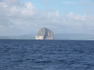 ark on the British side figured out that this rock, just around the corner from the current capital Fort de France, was a good place to station a ship. Rather than going to the hassle of building a ship and sailing it all the way over, they decided to commission the rock as a ship in the Royal Navy. So they loaded it up with canons and men and whatever else they needed and made a real nuisance of themselves to the French going about their business.
Now the fellah in charge of France at the time was not one bit pleased. Aside from the fact that all his nice ships were getting turned into match sticks, Martinique, indeed an estate in the near vicinity of Diamond rock, was home to a certain lady friend of his by the name of Josephine. Now this chap, Napolea n, was renowned as one of the most proficient soldiers of his time, but unfortunately for him, naval matters were not his forte. He sent his naval head honcho, Admiral Villeneuve, off to boot the Brits off the rock, and destroy all their boats while he was at it. This latter was a tad optimistic, seeing as how the Brits had more ships and bigger ships and knew how to use them.
So Villeneuve set off, sneaked passed Nelson's ships, took back Diamond rock, and went home. Not good enough for Napoleon who wouldn't buy the "I didn't catch that other bit boss", and Villeneuve was re-dispatched to complete part 2. He met up with Nelson at a place called Trafalgar, which is down near Cadiz, and promptly got his backside kicked. However Villeneuve survived the battle, Nelson didn't.
There's not much to see these days on Diamond rock, it's a pretty steep cone shaped thing a few hundred feet tall. We sailed by pretty close to it and took a few pictures. Those above show the rock from up close, and the distance shot from the small town of St Annes across the mouth of Le Marin bay.
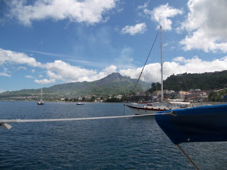
The second thing in Martinique that I didn't want to miss was the former capitol, St Pierre, situated temptingly at the foot of an active volcano. We were lucky when we there that the volcano top was not covered in cloud, we were told it usually is, see picture.
 Now the Caribbean gets its name from the Caribe Indians, who were the people that lived there before the Europeans arrived and were fierce and noble warriors. The story goes that rather than let themselves be enslaved they fought virtually to the last man, and the final few threw themselves into volcano. Before they did they cursed the invaders calling on the mountain to erupt and destroy them. That was 1658.
Now everyone in the Caribbean takes their time, and Mt Pelée is no exception. Just shy of 250 years later, on the 8th May 1902, at 8:02 a.m. to be precise, it didn't so much erupt as explode. It wasn't as if the locals didn't get any warning. Streams of molten lava flowed down the mountain for a month or so beforehand, and seeing more than a few of their neighbours killed, about a thousand of the town's residents thought it a good idea to get out of Dodge. Amazingly, the bulk of the population, about 30,000 people, stayed put. You see, some of the merchants in town figured evacuation would be bad for business, also there was an election coming up, the Governor was fairly new to the job, and moving everyone out was going to be a real pain. So they formed a committee and let them worry about it.
Depending on whose report you read there were either one or two survivors. By all accounts Cyparis was one. Apparently he was in prison for murder, and was in a stone cell in the basement of the town gaol. He lived out his days working as a freak show for Barnum's circus in the US showing off his burn scars, presumably having been released for lack of witnesses!
The other survivor according to some accounts was a cobbler called Leon Leandre, who happened to be in his cellar.
Twelve ships anchored off the town were destroyed, one managed to get away with a few survivors. The town itself was leveled, with barely a few walls left standing.
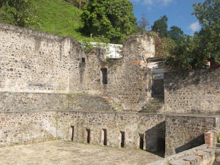
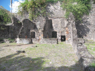
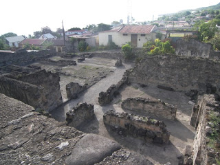
Today St Pierre is a town of about 5,000 people, there is a museum that commemorates the tragedy with pictures before and after the eruption, and some interesting artifacts. A large brass bell, contorted, ripped and twisted takes centre stage, there are also perfect rectangles of nails and screws welded into the shape of their container by the time it was incinerated.
We also visited the capitol Fort de France where we met an interesting Kiwi called Richard and his dog Trouble. Richard had arrived in the Caribbean seven years ago crewing for "a mad Norwegian" (his words), found himself an old 9 metre steel boat, patched it up and has been living a kind of Crocodile Dundee lifestyle since, trading with the Indian natives up the Oronoco river in Venezuela, and selling on their wares to tourist shops while cruising the Caribbean. He took us through the city on a hunting/gathering mission looking for coconuts and mangos. I suppose that's just gathering really. We had better success with the mangos, finding a half dozen or so windfalls at the edge of a park. We didn't do so well at the coconuts as the park keepers had been out clearing up the area he'd previously found. Eventually we found one that wasn't rotten or previously part eaten by local wildlife on a pathway through some apartments, it had to have been a very fresh windfall, as it wasn't there when we'd passed that way fifteen minutes before. Richard then produced a machete and proceeded to chop it open for its milk. The machete was a bit on the blunt side, and the operation took quite a bit of hacking, much to the amusement of the apartments' residents watching us from their balconies. Eventually we shared first the milk, then the meat of the coconut.
We made a last visit to Le Marin for some final provisions before leaving Martinique for St Lucia. It is now early May, and coming to the end of the season in which 'urricanes 'ardly hever 'appen, it's time to get south of the hurricane zone.
The first of these is Diamond rock. There's a phrase in our cruising guide that appealed to me, which goes something like "back in the days when Europeans used to go around in wooden boats taking pot shots at each other ....", written by an American I presume. Anyway, back in those days some bright sp
 ark on the British side figured out that this rock, just around the corner from the current capital Fort de France, was a good place to station a ship. Rather than going to the hassle of building a ship and sailing it all the way over, they decided to commission the rock as a ship in the Royal Navy. So they loaded it up with canons and men and whatever else they needed and made a real nuisance of themselves to the French going about their business.
Now the fellah in charge of France at the time was not one bit pleased. Aside from the fact that all his nice ships were getting turned into match sticks, Martinique, indeed an estate in the near vicinity of Diamond rock, was home to a certain lady friend of his by the name of Josephine. Now this chap, Napolea
 n, was renowned as one of the most proficient soldiers of his time, but unfortunately for him, naval matters were not his forte. He sent his naval head honcho, Admiral Villeneuve, off to boot the Brits off the rock, and destroy all their boats while he was at it. This latter was a tad optimistic, seeing as how the Brits had more ships and bigger ships and knew how to use them.
So Villeneuve set off, sneaked passed Nelson's ships, took back Diamond rock, and went home. Not good enough for Napoleon who wouldn't buy the "I didn't catch that other bit boss", and Villeneuve was re-dispatched to complete part 2. He met up with Nelson at a place called Trafalgar, which is down near Cadiz, and promptly got his backside kicked. However Villeneuve survived the battle, Nelson didn't.
There's not much to see these days on Diamond rock, it's a pretty steep cone shaped thing a few hundred feet tall. We sailed by pretty close to it and took a few pictures. Those above show the rock from up close, and the distance shot from the small town of St Annes across the mouth of Le Marin bay.
The second thing in Martinique that I didn't want to miss was the former capitol, St Pierre, situated temptingly at the foot of an active volcano. We were lucky when we there that the volcano top was not covered in cloud, we were told it usually is, see picture.


 Now the Caribbean gets its name from the Caribe Indians, who were the people that lived there before the Europeans arrived and were fierce and noble warriors. The story goes that rather than let themselves be enslaved they fought virtually to the last man, and the final few threw themselves into volcano. Before they did they cursed the invaders calling on the mountain to erupt and destroy them. That was 1658.
Now everyone in the Caribbean takes their time, and Mt Pelée is no exception. Just shy of 250 years later, on the 8th May 1902, at 8:02 a.m. to be precise, it didn't so much erupt as explode. It wasn't as if the locals didn't get any warning. Streams of molten lava flowed down the mountain for a month or so beforehand, and seeing more than a few of their neighbours killed, about a thousand of the town's residents thought it a good idea to get out of Dodge. Amazingly, the bulk of the population, about 30,000 people, stayed put. You see, some of the merchants in town figured evacuation would be bad for business, also there was an election coming up, the Governor was fairly new to the job, and moving everyone out was going to be a real pain. So they formed a committee and let them worry about it.
Depending on whose report you read there were either one or two survivors. By all accounts Cyparis was one. Apparently he was in prison for murder, and was in a stone cell in the basement of the town gaol. He lived out his days working as a freak show for Barnum's circus in the US showing off his burn scars, presumably having been released for lack of witnesses!
The other survivor according to some accounts was a cobbler called Leon Leandre, who happened to be in his cellar.
Twelve ships anchored off the town were destroyed, one managed to get away with a few survivors. The town itself was leveled, with barely a few walls left standing.
Today St Pierre is a town of about 5,000 people, there is a museum that commemorates the tragedy with pictures before and after the eruption, and some interesting artifacts. A large brass bell, contorted, ripped and twisted takes centre stage, there are also perfect rectangles of nails and screws welded into the shape of their container by the time it was incinerated.
We also visited the capitol Fort de France where we met an interesting Kiwi called Richard and his dog Trouble. Richard had arrived in the Caribbean seven years ago crewing for "a mad Norwegian" (his words), found himself an old 9 metre steel boat, patched it up and has been living a kind of Crocodile Dundee lifestyle since, trading with the Indian natives up the Oronoco river in Venezuela, and selling on their wares to tourist shops while cruising the Caribbean. He took us through the city on a hunting/gathering mission looking for coconuts and mangos. I suppose that's just gathering really. We had better success with the mangos, finding a half dozen or so windfalls at the edge of a park. We didn't do so well at the coconuts as the park keepers had been out clearing up the area he'd previously found. Eventually we found one that wasn't rotten or previously part eaten by local wildlife on a pathway through some apartments, it had to have been a very fresh windfall, as it wasn't there when we'd passed that way fifteen minutes before. Richard then produced a machete and proceeded to chop it open for its milk. The machete was a bit on the blunt side, and the operation took quite a bit of hacking, much to the amusement of the apartments' residents watching us from their balconies. Eventually we shared first the milk, then the meat of the coconut.
We made a last visit to Le Marin for some final provisions before leaving Martinique for St Lucia. It is now early May, and coming to the end of the season in which 'urricanes 'ardly hever 'appen, it's time to get south of the hurricane zone.
Subscribe to:
Posts (Atom)