Earlier in the season the systems formed off the African coast every couple of days and came rolling across the ocean straight at us here in Grenada, then usually at or before a few hundred miles off they’d skew northwards, turn into tropical storms/hurricanes and blast someone else instead of us. I felt like a skittle in a bowling alley that knew the guy playing couldn’t bowl for nuts, but concerned that he might fluke one. Still we had so much advance warning that we could always run south out of the way.
Later in the year, like now, the systems don’t get organized until they are close to our longitude. On Thursday night we got word that some bad weather was heading our way, on Friday morning tropical storm Tomas was born, predicted to hit us about midnight, with some of the more panicky forecasts predicting we were to be hit by six in the evening. So no time to run, just dig in wherever you are. As it happened we had come into a marina to do some work. So I had a half dozen unfinished jobs about the boat, on deck, on the pontoon. We had to stow everything.
I would have preferred to be at anchor. Then all I’d have had to do was put out all my anchors and clear the decks. At home the marinas are built of sturdy stuff inside of nice strong harbours, here not all of them are so sturdy, and this one is just in the bay, no harbour. In 2004, Ivan, a category 3 hurricane, sent this entire marina into the mangroves. However Tomas is a far cry from a category 3 hurricane, and we are fortunate in that there is no boat beside us, so we were able to tie to marina fingers on either side of us. I quadrupled my lines, 2 warps and 2 springs out of each of the four corners of the boat, and a few more lines besides. I was pretty knackered by the time we’d finished clearing away all the half done jobs, and I was in bed sleeping like a baby by 8.
And then the weather came! Or more correctly it didn’t! At least not to us. Sure, Barbados got hammered, but here, well it went all grey, and there were quite a few showers on Saturday. The weather gurus were astonished that we were reporting flat calm, no wind at all when they had predicted 40+ knots, gusting to 60. However they assured us of winds of 20 to 40 knots Saturday night. Well they were consistent : Wrong again! Another eerily calm night. It’s a strange feeling, to be within a hare’s breath of this monster, it smashing another country to pieces a short distance away, while we cower under a rock hoping it won’t come for us.
Another strange thing, my own sentiments, shared by just about everyone I talk to. Relief certainly, but tinged with an almost disappointing anticlimax. I mean we spent all day Friday building up our fortifications, psyching ourselves up for a life and death struggle against one of Natures worst tantrums, and then nothing! I mean there I was, looking forward to a lifetime of boring every dinner party with how I tackled hurricane Tomas when he was only a mere lad of a tropical storm. And then the little fucker didn’t show up!
Sunday, October 31, 2010
Monday, October 25, 2010
Pictures
So, I've finally gotten the finger out and downloaded Picasso to post my pics online. See http://picasaweb.google.com/103937943251204013492
Grenada
Grenada is a small Caribbean country of only about 100,000 people, with as many again living abroad, and whose remittances home make up a sizable portion of the countries income, echoes there of our own Irish economy of just a half century ago and before.
The people here are either descended from the African slaves brought here before the early part of the 19th century to work the sugar cane industry, or from Indian indentured workers (people who were sold into slavery by their own families or even sold themselves for their families benefit) to do the same work after "slavery" was abolished here in the 1820s.
But this is a country that stimulates the senses and emotions like no other I have been to. The beauty of its deep green jungles, spectacular waterfalls, a city of uncannily small but charming buildings, spice markets, and everywhere, even six years later, the sadness of the still evident destruction of Ivan, a category 3 hurricane that struck here in September 2004.
For Boaters, the most sheltered anchorages are in the many bays on its salamander shaped south coast. These deeply indented inlets are protected by land on three sides, and at the mouth by a zig-zag of reefs that require your full attention on entry and exit. Another advantage is the proximity to the capital, St Georges, at EC$2.50 each way (approx US$0.85/ €0.65), the twenty minute ride in buses that come every few minutes, make the city very accessible. The twenty minutes is provided that the driver doesn't decide he hasn't enough passengers, otherwise you can spend a further twenty minutes cruising the by-roads in search of more passengers. In this latter event, one adopts a Caribbean "Don't worry" mentality.
The capital St Georges is crowded around a double natural harbour, consisting of the city centre Carenage and the now almost completely marinafied Lagoon. Prior to Ivan the cruise ships came right into the Carenage, with its multitude of tiny spice shops and markets. Indeed another sad reminder of the hurricane is the new cruise ship dock outside the harbour and its shopping malls, together having all the character of an airport departure lounge. What an awful pity just a fraction of the money could not have been spent on the Carenage, which has instead been left to decline, with “Rum runner” tour boats attracting lowest common denominator tourists with deafening music that murders this beautiful place.
But Grenada's greatest asset is undoubtedly its people. On checking in to Grenada, the young customs officer told us they had the lowest crime in the Caribbean. What an understatement! A cruiser here recently came on the early morning VHF network to tell how his lost wallet had been returned to him, complete with contents!
Other examples of the bona fides of the locals friendliness are obvious as you walk around any of the towns. Zebra crossings are plentiful, and if you attempt to cross at them the first car will immediately stop. More, if you attempt to cross where there is no pedestrian crossing, they'll still stop for you.
There is a lady called Jan Pascal, who runs a "reading group" on Saturday mornings for kids that have fallen behind. The class is in Mount Airy about 6 or 7 miles outside of St Georges in the surrounding hills. By and large these are not backward children, but possibly through inadequacies of the education system or a cultural lack of emphasis on education, they were left behind. Sometime in the past a relationship developed between this group and the sailing community, and a busload of us go up there every Saturday to help the kids with the three Rs.
While teenagers are as they are anywhere in the world, I can't help but being struck by their good manners and politeness.
Recently, I was making slow progress in the mid-morning heat climbing the steep hill from the chandlers to my bus stop, where a bus was patiently waiting. When I got to within earshot, I called my destination, “Woburn”. “Sorry, next bus” came the reply and the bus went on. A taxi leaving the adjacent station called to me, “you going to Woburn?” Now my budget does not stretch to taxis when there's a perfectly good bus service, so I declined, a little irritated at the hussle. The taxi man's next words left me both charmed and ashamed as he said, “No man, I'm just going home for lunch, I can drop you, no charge”. His name was Rock, and I took him up on his offer.
The following afternoon, I left Catherine in St Georges, agreeing to meet up in Woburn. I took the opportunity while I was waiting for her to have a cool beer in Nimrod's rum shop, where pretty soon I was engaged in conversation with Nimrod and the only other customer, Rollo. Rollo not only insisted on buying me beer, but made it difficult for me to return the compliment. Our conversation covered quite some breadth, from the quality of beer brands to my anecdote about the generous taxi man, to his job on a very glamorous looking 60 foot ketch moored in the marina. My new friend's generosity was not restricted to me, Catherine on her arrival receiving the same treatment.
As we finally left, I confess a little unsteadily on my part, Rollo called after me, “Hey man, you know your friend Rock, the taxi man?” and without waiting for an answer, “He's my brother!”
I have only today installed picasso, Google's picture sharing program, and I have used it to post pictures from Mt Airy, and many other places in Grenada (and from previously in our adventure). Check it out on;
http://picasaweb.google.com/103937943251204013492
the dreaded Dengue
It was late July. We had the boat stocked up and were waiting for a decent forecast to head for Venezuela, but there had been no wind now for about a week. Then Catherine had been unwell over Wednesday night and she was no better Thursday, so we decided that she'd visit the doctor on Friday. Going to bed, I dismissed the beginnings of a headache I was feeling as the result of the stresses of the day. Neither of us slept well, and my headache got progressively worse, by morning there were two of us for the Doc, and he was quick to confirm our fears that we both had Dengue.
He gave us a prescription, each tablet contained 500mg paracetamol and 30 mg codeine, take one or two up to four times daily. Outside the pharmacy we both gobbled up two tablets each like bold children.
We normally do our week's shopping on Friday, so we forced ourselves around the supermarket, the drugs effective against the headache, but combined with the fever to turn us into zombies. For most of it we shouldn't have bothered, Catherine had already lost her appetite, and I was losing mine, I managed a small meal on Friday and Saturday before the nausea took hold.
I'm not sure when the headache went away, but by Sunday I was too nauseous to notice. The nausea and fever continued all week, while at the same time I went through a few days constipation, followed by a few days of diarrhea. I found that lying down the nausea abated some, and taking two of the tablets every six hours ensured that I was asleep, or at least not conscious, for a good 15 hours a day.
By Monday, the trip from bed to heads, a journey of perhaps 20 feet, I found impossible without a five minute lie down rest en route. By Wednesday we were getting concerned at our lack of nutritional input. I had been managing a glass of orange juice every day, but Catherine's diet was 100% water, the only things we thought we might be able to stomach, chicken broth and toast, meant a couple of minutes standing in the galley. By Thursday, taking it in turns we were able to do this. Chicken noodle cup of soup, diluted by 50%, and a slice of toast, heavily buttered, after fasting for a week I've got to have a few credits in the cholesterol bank!
On Friday, a neighbouring boat offered to do some shopping for us, although we needed little more than bread for toast and chicken noodle cuppa-soups, we were very grateful, neither of us was up to a trip to the shop. Over the weekend we progressed to eating boiled eggs (spooned out of their shells into a cup, with cholesterolly suicidal amounts of butter, yum! – I was never really responsible with credit).
On Tuesday we ventured out on the dinghy, just as far as the Marina at Calvigny, perhaps a half a mile dinghy ride. By the time we got there we were exhausted, but after a mineral and a rest in the big comfy chairs by the pool we were sufficiently restored to contemplate a light lunch, our first real meal in almost two weeks.
By the next Friday, two weeks after we had gotten sick, we were fit enough to do our own shopping, Today, four weeks on, we were still not quite back to normal, tiring easily and are still feeling a bit lethargic, but getting better all the time.
Although we got one of the less dangerous strains, Dengue fever is still one nasty disease, we had the bad luck to both get it at the same time. Perhaps the infecting mossies are hunting in packs!
Saturday, July 3, 2010
Cruising the Caribbean, St Vincent and the Grenadines
North Atlantic
View Larger Map
Caribbean
View Larger Map
Leewards & Windwards
View Larger Map
The Windwards refer to the island chain from Martinique in the North to Grenada in the South. The Leewards are the islands from Dominica north.
Martinique
View Larger Map
Martinique is a Department of France. We chose it as our arrival point after the Atlantic crossing because we thought it would be like arriving in France. Well, some French people we met described it as "Yes, it's France, but it's not France". To me the place felt more like a French speaking third world country, although a pretty affluent third world country at that.
We stayed for a total of 6 weeks, partially to recover from the crossing, partially to make repairs to the things that broke on the way over, and of course to visit the island & see the sights.
Martinique, Le Marin
View Larger Map
This is a deeply indented bay in the southeast tip of the island. For anyone in a boat, this means lots of shelter. There can be some fairly big waves out at sea, but short of hurricane conditions the bay is like a lake, so no rolling around in the swell. However, it also means lots of boats. There is a 600 berth marina, and up to twice that number of boats anchored off. There are some more isolated spots around the bay, if you don't mind the long dinghy ride into town.
At least one river flows into the bay, so the water is a bit murky. Because of the murkiness and all the boats, we never felt comfortable about swimming here. We moved out to St Anne (scroll above map down slightly) at the entrance to Le Marin bay to scrape off the goose barnacles that grew on our hull while we were crossing the Atlantic. However we had to put up with rolling around in the swell while we were there.
Martinique, Fort de France
View Larger Map
A little further North is the capital of Martinique, Fort de France. Although also sheltered from the elements, the anchorage is right beside the ferry terminal, and with ferries coming and going every few minutes from early morning through until evening it got very rolly from their wakes.
Although a much bigger town than Le Marin, it is nowhere near as yacht friendly. There is one chandlers, and plenty of supermarkets, pubs etc., but it is a town focused on being capital of the Island, rather than on the boats anchored off.
St Pierre
View Larger Map
St Pierre in the North, is virtually not sheltered at all, but worth a visit in calm weather because of the volcano and its history.
St Lucia
View Larger Map
This is the next island south in the Windwards. It is an independent country.
Near to the northern tip on the West coast there is a reasonable anchorage in Admiralty Bay, which is the area just south of Pigeon Island. It is open to the West, but the winds normally don't come from that direction.
View Larger Map
However the lagoon just off it, Rodney Bay, is a natural harbour, and is sheltered from all directions. Nowadays, the lagoon is filled with a couple of marinas, private docks on shoreside properties, and what space is left over is taken up with moorings. So it is no longer possible to anchor there.
The "Googlemaps" version of Marigot Bay is nothing like the place we visited, so I won't bother sticking up their map.
Soufriere and the Pitons.
View Larger Map
Soufriere is a pretty town, dominated by the Pitons, twin volcanic peaks that provide a dramatic foreground to the landscape. The whole area is a national marine park, and anchoring is forbidden. Moorings are provided for about EC$20, = about €6.50, a night. We picked one up about half a mile west of the town, in an area with the unlikely named of "the Bat Cave"!
There is a customs office in Soufriere where we were able to check out of St Lucia before departing for St Vincent.
St Vincent and the Grenadines
View Larger Map
The big Island in the north of the above map is St Vincent, and the Grenadines are the collection of little ones running south from it. All except the biggish island in the South of the map, and one of the tiny islands off it, which are Carriacou and Petit Martinique respectively, which are part of the country of Grenada.
We were advised that the entire northern half of St Vincent is cannabis growing country, lawless, and if we stopped there we would almost certainly be boarded by armed robbers. So we kept going until we reached a small bay about half way down the west coast called Wallilabou. Here there is a customs office, a hotel, a museum, and nothing else. Nothing that is, except the remains of the film set from the Pirates of the Caribbean. In fact the museum was part of the set, with nothing but a facade held up by scaffolding hidden behind it. But they put a roof over the scaffolding and made it weatherproof, then filled it with photos and other memorabilia from the making of the movies.
Again Googlemaps shows Wallilabou in the wrong place, so no point in zooming in on the map.
Here are some pictures we took there, see if you can spot anything familiar from the movies.


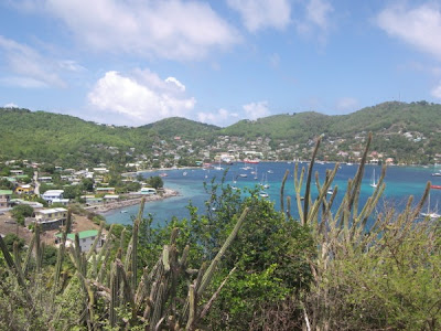
We didn't stop anywhere else in St Vincent, instead heading for our first Grenadine, Bequia. The massive sheltered bay on the west coast at Port Elizabeth makes it a popular spot for yachts.
View Larger Map
Looking at the map, the entire island looks like a harbour built around the anchorage. If you're wondering why all the anchorages are along the west coasts of the various islands it is because the trade winds blow almost constantly all year round from the east, so the West coasts are the sheltered side.
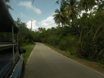
We met up with an American couple, Bill & Susan, and the four of us took a taxi on an island tour. Well, they call them taxis here, at home they call them pick up trucks, you just climb up on the back. Our taximan took the job to heart, and was proud to tell us about his island.
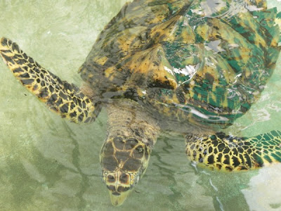
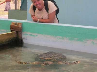
The tour also took in a turtle rescue centre. Pictures show the taxi, the anchorage, and a few sites from around the island.

Further south we visted the Tobago Cays, which are a handful of small islands and reefs. We anchored behind the reefs facing East into the Atlantic, the reefs protect you from the swell, but with nothing but ocean in front of us for two thousand miles to Africa. Sitting in the trade winds kept our wind generator spoinning, and it was great to see full batteries all the time.
View Larger Map
Caribbean
View Larger Map
Leewards & Windwards
View Larger Map
The Windwards refer to the island chain from Martinique in the North to Grenada in the South. The Leewards are the islands from Dominica north.
Martinique
View Larger Map
Martinique is a Department of France. We chose it as our arrival point after the Atlantic crossing because we thought it would be like arriving in France. Well, some French people we met described it as "Yes, it's France, but it's not France". To me the place felt more like a French speaking third world country, although a pretty affluent third world country at that.
We stayed for a total of 6 weeks, partially to recover from the crossing, partially to make repairs to the things that broke on the way over, and of course to visit the island & see the sights.
Martinique, Le Marin
View Larger Map
This is a deeply indented bay in the southeast tip of the island. For anyone in a boat, this means lots of shelter. There can be some fairly big waves out at sea, but short of hurricane conditions the bay is like a lake, so no rolling around in the swell. However, it also means lots of boats. There is a 600 berth marina, and up to twice that number of boats anchored off. There are some more isolated spots around the bay, if you don't mind the long dinghy ride into town.
At least one river flows into the bay, so the water is a bit murky. Because of the murkiness and all the boats, we never felt comfortable about swimming here. We moved out to St Anne (scroll above map down slightly) at the entrance to Le Marin bay to scrape off the goose barnacles that grew on our hull while we were crossing the Atlantic. However we had to put up with rolling around in the swell while we were there.
Martinique, Fort de France
View Larger Map
A little further North is the capital of Martinique, Fort de France. Although also sheltered from the elements, the anchorage is right beside the ferry terminal, and with ferries coming and going every few minutes from early morning through until evening it got very rolly from their wakes.
Although a much bigger town than Le Marin, it is nowhere near as yacht friendly. There is one chandlers, and plenty of supermarkets, pubs etc., but it is a town focused on being capital of the Island, rather than on the boats anchored off.
St Pierre
View Larger Map
St Pierre in the North, is virtually not sheltered at all, but worth a visit in calm weather because of the volcano and its history.
St Lucia
View Larger Map
This is the next island south in the Windwards. It is an independent country.
Near to the northern tip on the West coast there is a reasonable anchorage in Admiralty Bay, which is the area just south of Pigeon Island. It is open to the West, but the winds normally don't come from that direction.
View Larger Map
However the lagoon just off it, Rodney Bay, is a natural harbour, and is sheltered from all directions. Nowadays, the lagoon is filled with a couple of marinas, private docks on shoreside properties, and what space is left over is taken up with moorings. So it is no longer possible to anchor there.
The "Googlemaps" version of Marigot Bay is nothing like the place we visited, so I won't bother sticking up their map.
Soufriere and the Pitons.
View Larger Map
Soufriere is a pretty town, dominated by the Pitons, twin volcanic peaks that provide a dramatic foreground to the landscape. The whole area is a national marine park, and anchoring is forbidden. Moorings are provided for about EC$20, = about €6.50, a night. We picked one up about half a mile west of the town, in an area with the unlikely named of "the Bat Cave"!
There is a customs office in Soufriere where we were able to check out of St Lucia before departing for St Vincent.
St Vincent and the Grenadines
View Larger Map
The big Island in the north of the above map is St Vincent, and the Grenadines are the collection of little ones running south from it. All except the biggish island in the South of the map, and one of the tiny islands off it, which are Carriacou and Petit Martinique respectively, which are part of the country of Grenada.
We were advised that the entire northern half of St Vincent is cannabis growing country, lawless, and if we stopped there we would almost certainly be boarded by armed robbers. So we kept going until we reached a small bay about half way down the west coast called Wallilabou. Here there is a customs office, a hotel, a museum, and nothing else. Nothing that is, except the remains of the film set from the Pirates of the Caribbean. In fact the museum was part of the set, with nothing but a facade held up by scaffolding hidden behind it. But they put a roof over the scaffolding and made it weatherproof, then filled it with photos and other memorabilia from the making of the movies.
Again Googlemaps shows Wallilabou in the wrong place, so no point in zooming in on the map.
Here are some pictures we took there, see if you can spot anything familiar from the movies.


We didn't stop anywhere else in St Vincent, instead heading for our first Grenadine, Bequia. The massive sheltered bay on the west coast at Port Elizabeth makes it a popular spot for yachts.
View Larger Map
Looking at the map, the entire island looks like a harbour built around the anchorage. If you're wondering why all the anchorages are along the west coasts of the various islands it is because the trade winds blow almost constantly all year round from the east, so the West coasts are the sheltered side.
We met up with an American couple, Bill & Susan, and the four of us took a taxi on an island tour. Well, they call them taxis here, at home they call them pick up trucks, you just climb up on the back. Our taximan took the job to heart, and was proud to tell us about his island.
The tour also took in a turtle rescue centre. Pictures show the taxi, the anchorage, and a few sites from around the island.


Further south we visted the Tobago Cays, which are a handful of small islands and reefs. We anchored behind the reefs facing East into the Atlantic, the reefs protect you from the swell, but with nothing but ocean in front of us for two thousand miles to Africa. Sitting in the trade winds kept our wind generator spoinning, and it was great to see full batteries all the time.
Friday, June 11, 2010
Checking in and out
We're all used to Immigration and Customs controls in airports and ferry ports. You arrive into a country and there's usually one or two lots of officialdom you've to pass through, the guy that looks at your passport, (sometimes he stamps it and others he just nods vacantly as you hold it up as you pass him by), and then there's the “green” or “red” zones of “anything to declare”. We sometimes deal with the port authorities slightly more subtly in the “taxes” added to our air fares, but sometimes they collect a fee from you as well. But whichever the system, crossing an international borders has become a fairly streamlined, and the ports are set up to deal with arrivals by the boatload or planeload..
But supposing you are arriving in your own little boat, and your first port of call can theoretically be anywhere, as you can drop anchor off any piece of coastline. So there's a process.
Certain ports are designated as ports of entry, and you must make one of these your first port of call. On arrival you hoist a yellow flag. This flag represents the letter Q, for quarantine. Strictly speaking you then wait for officialdom to contact you, and traditionally they made sure you weren't bringing disease into the country. These days most places let the skipper come ashore, with passports and boat papers, and they check you in in the comfort of their office. Some places are even more flexible. However, friends of ours arriving in Morocco had to stay on their boat until a guy in a space suit came and checked them for swine flu, once passed, they were warmly welcomed into Morocco.
Within the EU, we didn't have to bother with checking in. Frequently, if and when you arrived at a marina the office passed on your details to whatever branches of officialdom required them, otherwise you were subject to random checks, which averaged for us about once every six months. However, the situation for non EU boats is probably different.
Outside of the EU the situation can vary. In Rodney Bay, St Lucia, the Immigration, Port, and Customs each had a desk in a tiny little office that you squeezed into. You filled out a form with three carbon copies, and then visited each desk in turn, leaving one copy and a little money with each official, keeping the last copy for yourself. In other places the offices are in different buildings, or even different towns, and it can be quite a run around. Even after you have gone through all of this in some countries, they require that you check in and out of every subsequent port you visit. In the Cape Verdes they even hold onto your boat papers while you're there. Most places only require that you check out when you are leaving the country.
Martinique was the simplest, where I just went into the customs office, sat at a PC and filled out an on-screen form, printed it, and brought it to the counter where it and our passports were stamped. The only odd thing there was that Martinique, as you may have read recently, is part of France (well a Department of France), and thus in the EU, where I as I previously implied they don't seem overly bothered with your papers at all.
One other document that they require when you arrive is your check out papers from the last country you've been to, so if you try to sneak in without paying the taxes and visas, you will have an unaccounted gap in your paperwork, so don't try it!
Beware though, if you think these little inconveniences tiresome with a mindset of countries like Ireland, Britain, France, etc., because when you get to the Caribbean most of the countries are smaller than a small Irish county, and crossing international frontiers is a routine event.
Caribbean Geography
The Antilles is the collective name for the Islands of the Caribbean, the Lesser Antilles being the smaller islands, that means excluding Cuba, Jamaica, and the single island that accommodates the countries of Haiti and the Dominican Republic.
View Larger Map
The Lesser Antilles are subdivided into the Leeward Islands, running as far south as Dominica, and the Windward Islands stretching from Martinique down to Grenada. I should point out, Dominica the island is a country onto itself, and is nothing to do with the Dominican Republic, except of course that they are both fellow Antilles.
St Vincent and the Grenadines is a country made up of one big Island, called “St Vincent” and a cartload of smaller ones, collectively known as the Grenadines.
Now to get all the confusing stuff out of the way, the Grenadines includes a group of islands and reefs called the Tobago Cays (pronounced “keys”), but does not include either the islands of Grenada or Tobago. If this is only a little confusing, fear not, tips of icebergs come to mind. Let's deal with the easy stuff first, Tobago the island is part of the country “Trinidad and Tobago” as opposed to the Tobago Cays (pronounced “keys”), which is still part of the Grenadines, and hence part of the country of St Vincent and the Grenadines.
The southernmost island in the Grenadines is Petit St Vincent, which is part of the Grenadines and therefore part of the country of St Vincent and the Grenadines, but nevertheless is quite distinct from St Vincent, which, though part of the same country, is not a Grenadine.
Now if you are Gaelic like me you might be inclined to think the Grenadines are like a collection of little Grenadas. Well, they are similar in climate, but Grenada, the island, is part of the country of Granada, which includes the islands of Grenada, Carriacou, and Petit Martinique. This last of course being completely separate to the island of Martinique a hundred miles or so further north, which is of course, part of France.
Subscribe to:
Posts (Atom)